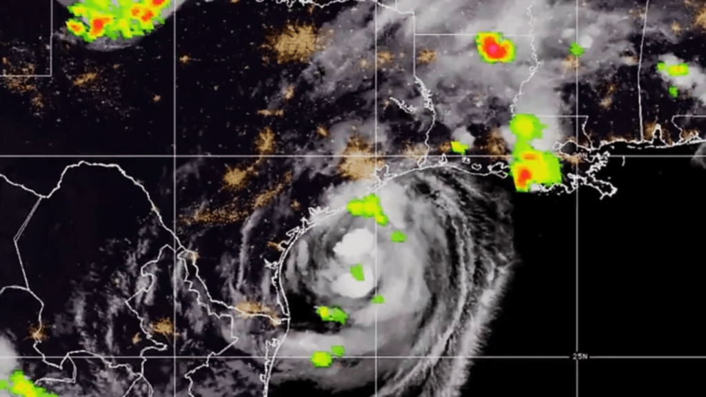
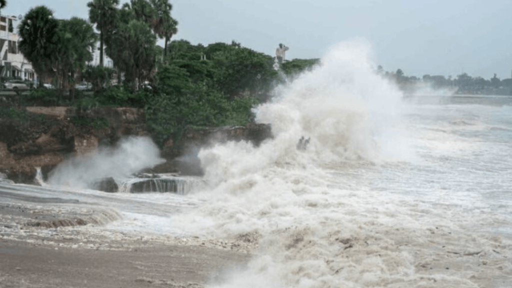
Hurricane Beryl reached the coast at 5 a.m. ET, accompanied by sustained winds of 80 mph. The storm’s renewed force and the expected storm surge are posing a significant threat to human life.

Hurricane Beryl has made a devastating landfall on the Texas coast, bringing with it life-threatening storm surges, flash flooding, and powerful winds. Early Monday morning, Beryl regained strength over the warm waters of the Gulf of Mexico and struck the Texas coastline at Matagorda Bay, situated approximately halfway between Corpus Christi and Galveston. This significant weather event has left forecasters and residents on high alert, with dangerous conditions expected to persist.
The Power of Beryl: Winds and Rain
The National Hurricane Center (NHC) confirmed that the eye of Hurricane Beryl reached the coast at 5 a.m. ET, accompanied by sustained winds of 80 mph. The storm’s renewed force and the expected storm surge are posing a significant threat to human life, with the NHC warning of storm surges up to 7 feet moving into normally dry areas along the coast from Corpus Christi to the Louisiana state line. These surges, coupled with up to 10 inches of rain in some locations, are predicted to cause severe flooding and damage.
Preparedness and Response
In anticipation of the storm, Texas state troopers have been preparing by filling sandbags in South Texas and boarding up homes. A growing number of counties in Texas, totaling 121 as of late Sunday, have been declared disaster areas by Acting Governor Dan Patrick. This declaration highlights the seriousness of the situation and the expected extensive damage.
The Houston Independent School District has announced closures for all its campuses on Monday and Tuesday, ensuring the safety of students and staff. The threat of tornadoes along the coast, spreading to East Texas, Louisiana, and Arkansas on Monday, adds another layer of danger.
Impact on Coastal Communities
The coastal community of Galveston has already experienced waves reaching 8 to 10 feet, creating hazardous conditions. The NHC has warned of “life-threatening surf and rip current conditions” along the Gulf Coast over the coming days. The path of Hurricane Beryl took it northwest across the Caribbean, at times as a Category 5 hurricane, before entering the Gulf of Mexico. After weakening over the Yucatán Peninsula, it regained strength in the warm Gulf waters and headed north toward Texas.
Casualties and Damage
Hurricane Beryl has already been blamed for at least nine deaths reported between July 1 and 4 in St. Vincent & the Grenadines, Grenada, Venezuela, and Jamaica. As of 1 a.m., Beryl is classified as a Category 1 hurricane with winds of 80 mph, making landfall at Matagorda just before 4 a.m. The storm’s impact is expected to continue throughout Monday, with meteorologist Caroline Brown emphasizing that this is just the beginning.
Widespread Effects
As Beryl gains strength, its core has tightened, concentrating hurricane-force winds along the coast. Communities such as Matagorda, Sargent, and Bryan Beach could see winds over 75 mph, while areas like Houston, Sugarland, The Woodlands, Liberty, and Katy are expected to experience winds ranging from 58 to 73 mph. These conditions could result in widespread power outages, downed trees, and potential damage to roofs.

Evacuations and Safety Measures
Local authorities have advised residents in the storm’s path to evacuate ahead of landfall. Many have boarded up windows, stocked up on supplies, and filled up on gas as they prepare to leave their homes. The storm made landfall on Mexico’s Yucatán Peninsula on Friday morning, affecting the Windward Islands and Jamaica earlier in the week, where it caused significant damage and loss of life.
Ports and Schools Closure
In anticipation of Hurricane Beryl, the U.S. Coast Guard shut the port of Houston on Sunday afternoon, along with the ports of Texas City, Freeport, and Galveston. Schools in Southeast Texas have issued closures for Monday as a precautionary measure. The Houston Independent School District, the largest school district in Texas, announced that all its schools and offices would be closed on Monday and Tuesday.
Expert Warnings and Advisories
Texas Lt. Gov. Dan Patrick urged residents not to underestimate the storm. “Don’t turn your back on Beryl,” Patrick warned in a CNN interview. “This is a serious storm, and where it lands, there’s going to be significant devastation. Power will be out. Structures will be blown over and destroyed. Streets will be flooded by heavy rain, so take this storm very seriously.”
Predicted Path and Future Impact
Meteorologists have predicted that the greater Houston area, particularly the western half of the metro area, will see significant effects in the form of strong, battering winds and heavy rainfall. Rainfall totals could reach 15 inches in some areas, leading to flash flooding. Acting Governor Patrick has issued a disaster declaration for 120 central and eastern counties, emphasizing that Beryl’s dangers go beyond its powerful winds.
Inland locations such as College Station and Texarkana, hundreds of miles from the coast, could also be subject to heavy rains and flash floods. Beryl’s track extends north to the Great Lakes, where it is expected to transition from a hurricane to a tropical rainstorm.
Continued Threats and Safety Precautions
AccuWeather meteorologist Dan Pydynowski warned that rain bands and squalls located to the east and southeast of Beryl’s center contain a lot of spinning motion, which can spawn tornadoes. Intense rain is also expected to affect Arkansas, Missouri, Illinois, and Indiana through Tuesday.
Officials from Texas have urged people who live inland to refuel, stockpile food and water, and maintain contact with friends and family. Lt. Gov. Patrick also recommended that residents keep up with updates and limit travel starting Monday.
Current Status and Future Predictions
As of 11 p.m. In the Gulf of Mexico, approximately 105 miles southeast of Corpus Christi, Texas, was located the center of Beryl, CT. The storm, with sustained winds of 75 mph, is expected to move northwest throughout Sunday, then turn north on Monday. Forecasters predict that it will make landfall on the Texas coast early Monday, with hurricane, tropical storm, and storm surge watches and warnings in place along Texas’ Gulf Coast.
Storm surges in Texas could reach as high as 7 feet from Port O’Connor to Matagorda Bay and San Luis Pass. Rainfall totals are forecast between 5 to 10 inches, with as much as 15 inches in some locations.
Summary
Hurricane Beryl has already set records, becoming the earliest Category 5 hurricane on record and the first June major hurricane east of the Lesser Antilles. As the storm continues to impact Texas and beyond, residents are urged to take all necessary precautions and stay informed through official channels. The full extent of Beryl’s impact will unfold over the coming days, with the potential for significant damage and disruption across the region.
Read More:

The Psychology of Love: Why Valentines Day Matters More Epic Than You Think
Discover the psychology of love and why Valentines Day is more important than you think. Learn how love impacts the brain, strengthens relationships, and boosts

Premier League Highlights: Arsenal Humiliate Man City 5-1, Spurs and Palace Secure Crucial Wins
Arsenal demolished Manchester City 5-1 in a statement premier league highlights win, reigniting their title hopes. Meanwhile, Crystal Palace stunned Man United 2-0, and Tottenham

How Budget 2025 Impacts the Indian Middle-Class: Major Tax Benefits and Glaring Omissions
Budget 2025 offers major tax relief to the middle class, including zero tax on incomes up to ₹12 lakh. However, it misses out on incentives

Degrees vs Employability: Why “Highly Qualified Degree Holders” Struggle to Find Jobs While “Less Qualified Individuals” Get Hired Faster!
Many highly qualified individuals struggle to secure jobs, while less qualified candidates get hired quickly. This Degrees vs Employability paradox is caused by employer preferences,

The Power of Mindset: Why Looking Poor Doesn’t Make You Poor, but Thinking Poor Does!
Discover why looking poor doesn’t define your wealth but thinking poor does. Learn the power of mindset and how a growth-oriented mindset can lead to

Overthinking: How It’s Damaging Today’s Youth – Causes and Cure in 2025
Understanding how overthinking is silently damaging today’s youth, from its causes rooted in societal pressure and social media to its long-term effects on mental health.
